
Bent: Adjective... determined, set, resolved. Noun... direction taken, inclination, capacity of endurance. Slang...recumbent bicycle.
Tuesday, January 18, 2011
Monday, January 17, 2011
The Other Slickrock
The Other Slickrock
Most everybody knows about Utahs infamous Slickrock. An abrasive, grippy, sandstone landscape that was once an ancient sea bed just north of the tourist town of Moab. Challenging, unique, mountain bike, dirt bike and 4x4 routes discernible only by dots and arrows painted on the stone that draws thousands of off road enthusiasts every year (except maybe 2020).
Few people know that Colorado has it's own Slickrock. The former bearing no resemblance to the latter. This is the story of my introduction to that slickrock. It occurred on day two of Ken and I's Colorado/Utah tour in May of 2009.
Day two and I was not well.
By the time we were ready for lights out that first night in CO, I knew I was in trouble. It felt as if a medicine ball was resting on my chest and the coughing was hurting now. It was a rough night and again I woke up unrested.Kens bike hadn’t made it on our flight. It wasn’t lost, just delayed. It had to be picked up at the airport at 10 or so the morning after our arrival. So while Ken went back to the airport to get it, I had time to build my bike and explore a little. Being under the weather, I appreciated the luxury of this bit of extra rest time. But We’d have to make up the mornings lost time somewhere in order to get back on our itinerary. By noon Kens bike was built.. By 1pm, lunch was just a memory and soon enough Grand Junction was too.
Highway 50 south took us 15kms to jtn 141 leaving about 70km to go for day ones ride. It was a beautifully scenic afternoon as we gradually made our ascent from 4500' to 7045'. We saw a herd of majestic mountain goats close to the road at one point. Traffic was nearly nonexistent and the red rock walls towered over us as we made our way up out of the canyon. I tried to ignore the sinus congestion, head ache, and burning chest. Normally a climb like this would've been fairly easy but I was definitely laboring. We reached the summit by 4:30 pm and after pausing to enjoy the moment, began the long, smooth, refreshing roll down to Gateway. Our days destination.
It was another rough nights sleep. I woke up feeling marginally worse.
We spent some time going over the map during breakfast trying to decide how best to get back on track of our itinerary. You see we had only a set number of days and a set amount of kms/day in order to conclude our proposed Grand Junction loop. It was only day two and we were already 80kms behind schedule. Where we wanted to be by days end was 250kms away with 2 alternate ways of getting there and no clear choice as to which would be the easier or shorter. This was March of 2009. A time before smart phones and easy access to travel info on the fly.
Either way, Naturita was to be our mid day destination. The Delores river flowed alongside 141 all the way to Naturita. We would follow it that far. Then we would have to decide.Exit 141 in favor of hwy 90 west, or stay riding south on 141 to Dove Creek before turning west. We didn't have any elevation profile maps to aid our decision. Both looked like a formidable amount of climbing would be involved.
On the outskirts of town we stopped for a photo op by the "welcome to Naturita" sign. Ken had his new Bacchetta recumbent on this trip and hadn't installed a kickstand yet so he wheeled up to the sign, rested his bike there and we set up a camera for the picture.
Now at this point in the story, I should point out that every ride has moments of discovery and moments that aid to reaffirm lessons already learned. Just as I knew it was silly to venture into buddies attic without a respirator but did it anyway and had my lesson reaffirmed, we knew better than to wheel our bikes off the pavement into the type of hearty brush that survives alongside the road in arid, sun parched country. (foreshadowing).
 At this point in the story I should probably mention that we had waffled back and forth trying to decide on our direction from Naturita and in so doing, got our facts about what was up ahead mixed up.

Before the trip began, as always before a trip begins, time seems to compress. That moment when I suddenly realize the “things do before I leave” list are at risk of becoming the “things I meant to do before I left” list.
So I’d gotten serious about ticking off tasks on the list and was getting down to the final few. One of them was to help a friend install a drop down, retracting staircase in the ceiling of his mud room so he could more easily access his attic.
This I had left until the day before my flight to Grand Junction CO. I thought it would be a simple task. Merely helping out. Maybe just holding something in place while Rick secured it or something. The muscle basically. Not the brains.
So I showed up somewhat unprepared.
What needed doing was for me to climb up into the attic, move insulation out of the area the staircase was going to come through and tap nails through the ceiling between the rafters where the hole was to be cut. I knew at this point that I should go home, get out of my shorts and t-shirt, put long sleeve shirt and pants on, grab a respirator and goggles, and head back. I knew this but I was feeling rushed and decided to just get it done.
Once up in the attic and over the area in question, I discovered 6 separate electrical lines ran over the chosen area and would have to be unfastened, moved and refastened elsewhere before any cutting could begin. This I did. Then moved the insulation while trying to hold my T-shirt up over my nose and mouth, tapped nails at the inside edges of the 2 foot wide span between the rafters. This took about an hour. Finally I climbed back down out of the attic and proceeded to cut the hole and install the prefab staircase. I helped clean up a bit before heading home for a shower.
It was stupid and careless of me to inhale so much attic, insulation, and drywall dust. I paid the price. My eyes ached, my skin itched, my throat and nose were sore and by 10 that evening I had a cough developing. I coughed all night and woke up unrested.
Unrested, but excited. Today was the day the Colorado/Utah bike tour began. Today my friend and I Would fly to Grand Junction, Utah and basically ride the Grand Circle Tour clockwise.
By the time we were ready for lights out that first night in CO, I knew I was in trouble. It felt as if a medicine ball was resting on my chest and the coughing was hurting now. It was a rough night and again I woke up unrested.
Highway 50 south took us 15kms to jtn 141 leaving about 70km to go for day ones ride. It was a beautifully scenic afternoon as we gradually made our ascent from 4500' to 7045'. We saw a herd of majestic mountain goats close to the road at one point. Traffic was nearly nonexistent and the red rock walls towered over us as we made our way up out of the canyon. I tried to ignore the sinus congestion, head ache, and burning chest. Normally a climb like this would've been fairly easy but I was definitely laboring. We reached the summit by 4:30 pm and after pausing to enjoy the moment, began the long, smooth, refreshing roll down to Gateway. Our days destination.
It was another rough nights sleep. I woke up feeling marginally worse.
We spent some time going over the map during breakfast trying to decide how best to get back on track of our itinerary. You see we had only a set number of days and a set amount of kms/day in order to conclude our proposed Grand Junction loop. It was only day two and we were already 80kms behind schedule. Where we wanted to be by days end was 250kms away with 2 alternate ways of getting there and no clear choice as to which would be the easier or shorter. This was March of 2009. A time before smart phones and easy access to travel info on the fly.
Either way, Naturita was to be our mid day destination. The Delores river flowed alongside 141 all the way to Naturita. We would follow it that far. Then we would have to decide.Exit 141 in favor of hwy 90 west, or stay riding south on 141 to Dove Creek before turning west. We didn't have any elevation profile maps to aid our decision. Both looked like a formidable amount of climbing would be involved.
On the outskirts of town we stopped for a photo op by the "welcome to Naturita" sign. Ken had his new Bacchetta recumbent on this trip and hadn't installed a kickstand yet so he wheeled up to the sign, rested his bike there and we set up a camera for the picture.
Now at this point in the story, I should point out that every ride has moments of discovery and moments that aid to reaffirm lessons already learned. Just as I knew it was silly to venture into buddies attic without a respirator but did it anyway and had my lesson reaffirmed, we knew better than to wheel our bikes off the pavement into the type of hearty brush that survives alongside the road in arid, sun parched country. (foreshadowing).
By the time the camera was packed away again Kens front tire was flat. We rolled 100 feet or so down the road to a shady spot and it was there he realized he had not packed a spare tube for his 20" front wheel. His rear was 26" as were both of mine and we had spares for them but he was reduced to patching the flat 20 incher. Normally we swap out the leaky tube for a fresh one, then patch the leaky one later in the evening while chilling out in the motel. The noise from passing traffic makes it near impossible to hear a leak but Ken did find it, patch it and reinstall it. A brief moment to gather up pump etc, congratulate each other and we were on our way. A moment later it was flat again. No near shade this time. We decide to wheel to the restaurant we spy up ahead and deal with it there. We order our food and Ken goes into the bathroom to use the sink to help find the leak and returns a long while later to proclaim discovering 3 more punctures in the tube and a bunch of tiny thorns in the tire. That delt with and lunch in our tummies we saunter back out to discover Kens rear tire is now flat.(no embellishing here. Not a word of a lie).
Anyway... Eventually we do actually get on our way again somewhere around 2pm with only 80kms behind us so far. We stop at a store in Dry Creek Basin, really not much more than a store at a crossroads and grab a juice.
Anyway... Eventually we do actually get on our way again somewhere around 2pm with only 80kms behind us so far. We stop at a store in Dry Creek Basin, really not much more than a store at a crossroads and grab a juice.
 At this point in the story I should probably mention that we had waffled back and forth trying to decide on our direction from Naturita and in so doing, got our facts about what was up ahead mixed up.
We decided not to replenish our water here or stock up on any snack food because there was a town (Bedrock) another 30k or so up the road. I would reflect back to this decision and mentally kick myself many times later in the day.
At the till, the cashier inquires curiously about our trip and says..." GOOD LUCK CYCLING OVER SLICKROCK". She said it in such a way that it made me look up at her. She was looking at us like we were dead men walking or something. One other customer was in the store and when he heard her comment he looked around at us and man if he wasn't giving us the same deadpan expression.
We both looked at each other on our way out into the sunlight and shrugged. On our way again, we rolled out into a valley. "Disappointment Valley" was it's name and it fit. The mountain range ahead of us slowly raised up out of the horizon and when we crested Gypsum Pass at 6100' we made the realization that the town "Bedrock"(the town we were going to replenish water at and stock up on some snack food) was on highway 90, not 141. Nothing was on 141 until Dove Creek. Dove Creek was still miles away. After the pass we rolled down into another valley and then the real climb of the day began.
Ken and I ride together a lot. But we don't ride side by side or close together all the time.
Especially during the climbs. We both have our own pace and times when one of us has more energy than the other. Usually it's Ken who slowly disappears in the distance during a long climb. Definitely this was one of those times. We started out together, but I was feeling so weak and coughing so deeply. My sinuses were fully stuffed, my head hurt, and my chest felt like a hot band was strapped across it. All this left me feeling breathless and dizzy. Slowly I dropped off his wheel. I made a few attempts to get back on it but eventually I just didn't have the steam to care.
Especially during the climbs. We both have our own pace and times when one of us has more energy than the other. Usually it's Ken who slowly disappears in the distance during a long climb. Definitely this was one of those times. We started out together, but I was feeling so weak and coughing so deeply. My sinuses were fully stuffed, my head hurt, and my chest felt like a hot band was strapped across it. All this left me feeling breathless and dizzy. Slowly I dropped off his wheel. I made a few attempts to get back on it but eventually I just didn't have the steam to care.
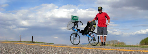
So I found myself alone as I rounded a corner and came upon a sign that said.."Slickrock"
I was out of water now, hadn't eaten anything for a few hrs, had no idea how far we had to go or how much more climbing to expect. I told myself it was just another climb. I love to climb. Usually go out of my way to incorporate them into a ride if I can.
I was out of water now, hadn't eaten anything for a few hrs, had no idea how far we had to go or how much more climbing to expect. I told myself it was just another climb. I love to climb. Usually go out of my way to incorporate them into a ride if I can.
There was a series of switchbacks that had reduced my speed to about 3kph. I looked up from my pedaling feet, from the asphalt flowing beneath my tires like a slow moving, murky river. I glanced around... Scenery changes slowly at that speed. There was still just the hill. The hill.... And me. I was still in granny gear (though I caught myself trying to click into it several times anyway), sweat was still glistening on my forearms, and I was still pointed up a 6% grade.
The backside of a sign I'd first glanced while rounding a switchback a couple hundred feet below still taunted me a couple hundred feet above. It would disappear from sight for awhile, then reappear marginally closer as I rounded another corner. It was a big sign. Had to be a sign of significance. The other signs I'd past on both sides of the road were much smaller. Signs cautioning speeds of 30mph. Signs warning of range cattle and deer migration routes, blind corners etc. This sign was different. Surely a summit sign. Congratulating me for my efforts and rewarding me with the promise of long sweeping downhill and speeds in excess of 70kph as the happy town of Dove Creek drew ever closer. That is what it must be. Had to be.
The size of it had me wondering though. I'd never seen a summit sign so large. Maybe the size of the sign increased with the level of difficulty.
I looked down at my feet again. Taking comfort in their cadence. Knowing that that indeed signified forward motion. I concentrated on my breathing and my cadence. Soon, except for the hill, that's all their was.
Ever since I was young, whenever I get really dehydrated I will start to visualized a bottle of coke. That's what pops into my head. A bottle of coke resting in a bucket of ice. Beads of condensation glistening on the glass. An old style bottle from the days before plastic and twist off caps. From the days before I knew or cared whether it was bad for me or not. Man how refreshing that would be right then. I started imagining that I'd find it sitting on the counter at an ice-cream stand under the giant summit sign. Yup, their neon open sign blinking open open open under the Summit Ice-cream sign. Today's special. The Summits Coke Float. I was gonna get 3 of em!
I chanced a glance up the road and had to smile. There, maybe 1000 meters ahead was the sign. The grade leveled off a bit and I actually found the reserves to click up a couple gears. Legs were pumping now. I guess a part of me knew as I drew alongside that sign that it had nothing to do with a summit. I knew and accepted before seeing it that my ordeal was not yet passed. The sign indicated a runaway lane for rigs. That's all. I didnt give the disappointment any energy. I didnt have any to spare.
I pushed on. Though i was still beaded in sweat like my imagined pop bottle, the shadows were now long and stretching across the road. I passed 2 more runaway lanes before the climbing tapered off and I could coast a bit. I never did see a summit sign. Nor was I rewarded with miles of sweeping descent. Merely a rolly polly road leading to the intersection where 141 meets 491. Ken was waiting for me there. It was dark. I think around 10pm. Dove creek was just 2 clicks to the east. Ken had already secured a room at the first, possibly only motel and scouted our dinner options. Only thing open was the gas station. I was spent, bonked, exhausted, couldn't eat, felt chilled and sick, near to puking. I apologized to Ken, got up and went to our room where I immediately curled up under the blankets with all my dirty cloths on and fell into a deep sleep
.
I woke up confused and ravenous in the middle of the night. I saw that Ken was asleep in his bed and remembered the food I had put on the table beside my bed before passing out. I had a litre of chocolate milk, a banana and an oatmeal raisin cookie that I had purchased on my way out of the gas station. I inhaled it all, undressed and went back to sleep.
I felt much better in the morning. Not cured or anything, but as it looked like I had survived, life was good. I recorded the previous days stats before zeroing my trip meter. 180k total, 4465' elevation gain, 10.5hrs ride time and 16kph average.
That was day two... Colorados Slickrock. It took us another two days to catch up to our itinerary.
Whatever it was I had contaminated myself with never left me the whole 14 days. Though it kinda receded I guess. 6days later we managed another 180k day with 7165' of gain in 9 hrs and I felt okay with it.
The entire trip consisted of 9 travel days totaling about 1600kms and 33,000' elevation gain.
We visited Moabs Slickrock and Porcupine Rim trail (on rented xc bikes) at the tail end of our trip and had a blast.
We visited Moabs Slickrock and Porcupine Rim trail (on rented xc bikes) at the tail end of our trip and had a blast.


When the trip was over, I had a relapse. Chest really started to hurt again and I went to my doctor. I definitely had a lung infection. He prescribed penicillin and within a few days I was 100%. What I would've given for that 2 weeks earlier.
Bruce Gordon
Globebent.org
Subscribe to:
Posts (Atom)